canuks

Saturday, February 23, 2008

Off to Nelson Once Again


This was another major driving day. We hit the road at 10:00 after a quick breakfast and headed north out of Franz Joseph. The rain that had started in the afternoon on the previous day continued through the night and was still going strong as we worked our way along the west coast of the south island.

The steady rain added a previously unknown dimension to the adventure that is the New Zealand winding mountain road. Fortunately there was light traffic heading south and especially little truck and bus traffic.

The highway parallels the coast several kilometers inland as it makes its way through the coastal mountains. The tires on our rental car were more than up to the task of the sharp turns, sudden braking, and uphill acellerations the road offered and I had a pretty good time for most of the trip. Debbie, on the other hand, watched the approaching hairpin turns and oncoming traffic with less confidence.

We stopped for lunch in Greymouth (the town where two years ago we caught the train for the trip over the mountains to Christchurch). One funny incident happened while we were walking down the street looking for a suitable lunch spot. After scoping out one cafe Debbie remarked that it was very similar to the one we had had lunch at while waiting for the train. After we walked out, I noticed a wall painting across the street that looked familiar and suddenly realized it was the exact same cafe.

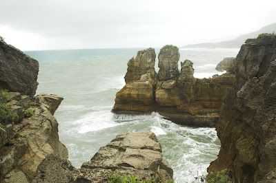
Once at the coast we chose a slightly longer route so as to pass by the Pancake Rocks area which is a recommended site to see. We probably would have skipped it this trip, but it seems likely we won't visit the west coast of the south island again even if we revisit New Zealand in the future, so it was a now-or-never choice and we chose now.

As we approached the park that comprises the Pancake Rocks site we found ourselves in a narrow tourist-y area without any indication we weren't on a major highway, even though we were. It just suddenly appeared and there were many tourists walking across the highway and tour buses parked beside the highway. They could really use some extra signage there, with perhaps a crosswalk or two.

The two attractions in the area are the pancake rocks and some blowholes resulting from waves pushing air through underground channels. We never saw the blowholes. I can't say why since I was kind of looking forward to seeing them and it was mighty wavey that day.

The "Pancake" nature of the rocks in the area is currently unexplained according to the signboards along the scenic walkway.


The walkway is paved and a fairly easy stroll for all ages (including a pair of pushy older ladies who kept jumping in front of me when I tried to take a pic)


The water has undercut the rock in places creating deep channels, sometimes with sea level holes for the waves to crash through.


Other than the unusual rocks ...


... the rainy weather ...


... and the stunning scenery ...


... there wasn't a whole lot else to see, so we finished the structured walk and continued on our way.

Debbie tried once again to capture the driving fun.


As we got near Nelson the mountains became a little less rocky and a bit more stoney. I thought it was amazing that these highway cuts through essentially dirt and gravel didn't have a bit more in the way of reinforcing wall to keep the walls from crumbling onto the road. This one had a fence, at least.


After a grueling drive, we finally made it to Nelson only to discover that it was the busiest weekend of the year. After driving around the city for a while we ended up finding the second last room in the city, which was a very nice, if very expensive room.

We settled in and then wandered to the downtown for some last minute (for Nelson - 9:00 pm!) dinner, had a pint and found ourselves in bed asleep by 10:30.

Until next time,

Don

Wednesday, February 20, 2008

New Posts

We will be heading up to the sailboat tomorrow so posts over the next few days will depend on my access to internet which if the weather is good, will be infrequent. If the weather continues to be cloudy and really windy as it has been for the last few days, we may be tied up to the dock in Russel the whole time, in which case I should be connected intermittently.

Don

Franz Joseph Glacier


We were told to make a 9:15 arrival at the Franz Josef Glacier Guides office for our 9:30 start, but frankly it wasn't clear what the extra 15 minutes was allocated for. The office was chaos and we waited around for a while before being collected up with 8 others to be herded across the street to be outfitted with boots and snow pants for the hike.

The people were very friendly and helpful and the equipment seemed to be in decent shape. We then waited around for a while longer until collected up to head to the helipad which is a few short steps off the main street. We then waited at the helipad for the helicopter to come to ferry us to the glacier. In all it was almost 10:20 by the time we were in the air. Despite all the delays, though, in addition to the helicopter rides the hike went on for a good 2 1/2 hours so we were not in any way disappointed with the excursion or the folks at Franz Josef Glacier Guides.


The helicopter pilot took us swiftly up the river (which is mostly melt water from the glacier) toward the face of the glacier.


The glacier looks very much like a river that has been flash frozen as it flows down between the mountains.


This is what they call the face of the glacier with the river flowing out of the base. The water is grey and silty due to the ground up rock that the glacier generates as it is forced down the mountainside. According to our guide the glacier moves 3 to 5 metres down the mountain each day, but because 2-6 metres of the glacier melt away each day there is little net movement of the face down the valley.


You can see by the shape of the deep crevasses that there are tremendous stresses on the ice as it is drawn and pushed down between the mountain walls.


The pilot flew close to the ice as the helicopter climbed rapidly up the glacier face. We were close but not that close - those spires of ice are huge.


That is a mini-glacier off in the distance pushing out between the rocks to add its ice to that of Frans Joseph.

The blue colour is not artificial. That's what the ice really looks like.

Debbie sat in the front with me in the back row of seats. Here is the view out the front as we rapidly approached the glacier (at over 200 kph - I checked on the GPS later).


This is the ice topology on the way up to the more level area we hiked on. One would definitely not want to hike through that!


And finally a view of the mountains near the summit which we flew over before heading back down to the hiking area.


The 10 of us in the hiking group were ferried up in two groups of 5. This is the first group of 5 waiting for us to arrive.


Once we had been deposited on the ice the helicopter took off to run other errands while we tramped around.


We were fitted with crampons (sharp ice treads for walking on ice) before heading off.


I ended up near the back as I was always stopping to take pictures. The guide, AJ (he's the one in shorts), called us Team Canada and often called back to encourage us to keep up.


Here is a shot showing a different hiking group somewhat up the hill from us just to give you some idea of the scale of the place.


The sun and melting water form a lot of these deep cuts and holes that you have to keep an eye out for to avoid stepping into them.


Here we are once again falling behind.


AJ led us up the hill as he searched for some larger ice caves.


We passed many smaller caves which make for some nice photographs.


We found one largish cave but it was deemed too unstable to enter so we just got as close as we could to see inside.


There is a streak of dirty ice covered with rocks and gravel running down the centre of the glacier. Apparently this is what was left behind after torrential rainstorms in early January created a massive river that ran over the glacier.


A couple of other groups, now.


Debbie, completely unafraid of slipping on the ice.


A shot looking up the hill toward one edge.


We eventually found a cave big enough and safe enough to walk through.


We hiked from there back to the rendezvous spot where the helicopter left us passing lots of interesting ice structures along the way.


While waiting for the helicopter to return after picking up the first 5 of our group we took a few (dozen) pictures. I will only fill this space with a judicious sampling of them, though.


As we waited in the bright sunshine on the glacier we could see the cloud cover moving in from town toward us. As we flew down the valley ...


... the cloud thickened and it began to rain.

The pilot approached the helipad with an acrobatic, stomach testing finish but landed us safely back in Franz Joseph. We returned our gear to the Glacier Guides and headed off for lunch.


We had a few hours remaining to kill after lunch so decided to head off to the glacier wall by car to hike around the river. The road ends a few km from the glacier itself at a large carpark. The main hike to the glacier wall itself was closed due to the rain which apparently causes the river to behave unpredictably. We thus chose a couple of the shorter hikes which end in scenic viewpoints. Because it was raining pretty heavily when we set out, I left the camera behind so even though the rain let up shortly thereafter, we have nothing to show except the memories.

Upon our return to the carpark we noticed a large bird screaming loudly at passers by. A woman walking by told us it was a Kea, and described them as "Cheeky Buggers" since they are quite bold and will steal and/or damage shoes and other small belongings.


We headed back to town and had a better dinner at the same restaurant before returning to our motel room for some TV and sleep.

Next: A rainy drive to Nelson.

Until then ...

Don